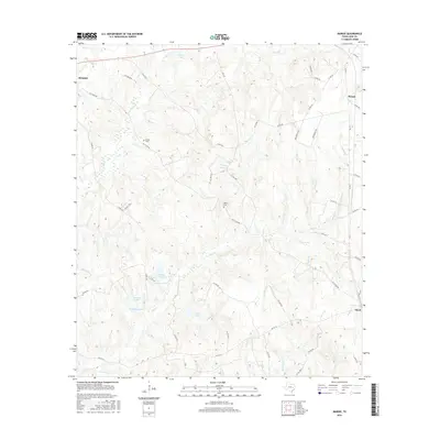
2016 Map of Margie
USGS Topo · Published 2016About this map
Marquez and Flynn anchor this pocket of Leon County, where the landscape is defined by a dense network of creek branches and small impoundments. The terrain is deeply etched by waterways like Pigeon Roost Cr and Buck Cr, creating a complex drainage pattern that has historically influenced the placement of rural roads. Several private and county roads, such as Old Flynn Rd, weave between these drainages, connecting scattered homesteads to the more established settlements. This area reflects a quiet, rural character typical of East Texas, where small lakes like Cheney Lake, Frossard Lake, and Ponderosa Lake are interspersed with family landmarks. For genealogists, the map provides precise locations for the Green Cem and White Cem, two key sites for tracing the early inhabitants of the Margie vicinity. The concentration of labeled "branches"—including Sand Br, Vestal Br, and Tomlin Br—illustrates the intricate hydrology that has shaped agricultural and property boundaries for generations.
Find a feature on this map
63 named features on this map. Tap any name to fly to it.
Don’t see what you’re looking for? This feature index may not catch every label — zoom into the map to look around manually.
Map Details
Editions of this 2016 Margie Map
This is the sole edition of this map. No revisions or reprints were ever made.
Other maps of this area

1925 · Marquez No. 1
USGS Topo · 1:48,000

1925 · Marquez No. 4
USGS Topo · 1:48,000

1927 · Marquez
USGS Topo · 1:62,500

1930 · Marquez
USGS Topo · 1:62,500

1954 · Waco
USGS Topo · 1:250,000

1955 · Waco
USGS Topo · 1:250,000

1956 · Jewett
USGS Topo · 1:62,500

1964 · Spring Seat
USGS Topo · 1:24,000
1964 · Normangee
USGS Topo · 1:24,000
1964 · Hilltop Lakes
USGS Topo · 1:24,000