
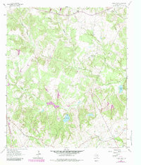
1964 Map of Spring Seat
USGS Topo · Published 1967About this map
The community of Flynn serves as a focal point in this portion of Leon County, positioned where the C R I & P and F W & D railroad lines traverse the southwestern corner of the quadrangle. This mid-1960s landscape is characterized by a dense network of creek branches, including Spring Creek, Boggy Creek, and Mustang Creek, which feed into localized water bodies like Lake Reed and Hayden Lake. The area's social fabric is anchored by small rural centers such as Redland and Spring Seat, each marked by their respective local institutions.
Find a feature on this map
25 named features on this map. Tap any name to fly to it.
Don’t see what you’re looking for? This feature index may not catch every label — zoom into the map to look around manually.
Map Details
Editions of this 1964 Spring Seat Map
2 editions found
Other maps of this area

1953 · Palestine
USGS Topo · 1:250,000

1954 · Waco
USGS Topo · 1:250,000

1955 · Waco
USGS Topo · 1:250,000

1956 · Jewett
USGS Topo · 1:62,500

1957 · Palestine
USGS Topo · 1:250,000

1964 · Centerville
USGS Topo · 1:24,000

1964 · Leona
USGS Topo · 1:24,000
1964 · Normangee
USGS Topo · 1:24,000
1964 · Hilltop Lakes
USGS Topo · 1:24,000

1964 · Margie
USGS Topo · 1:24,000