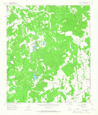
1964 Map of Hilltop Lakes
USGS Topo · Published 1967About this map
The master-planned resort character of Hilltop Lakes defines the northern reaches of this mid-1960s survey, showing a landscape transitioning from traditional Texas ranching toward recreation. Centered on a series of man-made water bodies including Mirror Lake, Kickapoo Lake, and Cherokee Lake, the development features a Golf Course and the Hilltop Landing Strip, signaling a specific era of private aviation-based communities.
Find a feature on this map
29 named features on this map. Tap any name to fly to it.
Don’t see what you’re looking for? This feature index may not catch every label — zoom into the map to look around manually.
Map Details
Editions of this 1964 Hilltop Lakes Map
2 editions found
Other maps of this area

1925 · Iola No 2
USGS Topo · 1:48,000

1925 · Marquez No. 1
USGS Topo · 1:48,000

1925 · Marquez No. 4
USGS Topo · 1:48,000

1927 · Marquez
USGS Topo · 1:62,500

1930 · Marquez
USGS Topo · 1:62,500

1931 · Iola
USGS Topo · 1:62,500

1954 · Waco
USGS Topo · 1:250,000

1954 · Austin
USGS Topo · 1:250,000

1955 · Waco
USGS Topo · 1:250,000

1962 · Edge
USGS Topo · 1:24,000