
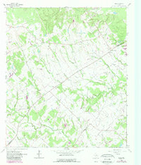
1962 Map of Edge
USGS Topo · Published 1964About this map
The community of Edge lies at the heart of this 1960s rural landscape, situated along the border of Robertson and Brazos counties. The map documents a predominantly agrarian region defined by a network of family cemeteries and small rural churches, such as Shiloh Ch and Shiloh Cem. The terrain is deeply incised by watercourses, including Cedar Creek and Devils Jump Creek, which dictated the early settlement patterns and the placement of local thoroughfares like Kings Highway. Small clusters of activity are visible at Eaton and Macey, while larger landholdings like Cavitt Ranch indicate the transition into larger-scale ranching. The presence of multiple burial grounds, including Anderson Cem, Concord Cem, and House Cem, provides a detailed record for genealogists tracing the local families who established these communities before the modern consolidation of rural Texas.
Find a feature on this map
35 named features on this map. Tap any name to fly to it.
Don’t see what you’re looking for? This feature index may not catch every label — zoom into the map to look around manually.
Map Details
Editions of this 1962 Edge Map
2 editions found
Other maps of this area

1925 · Iola No 2
USGS Topo · 1:48,000

1925 · Marquez No. 4
USGS Topo · 1:48,000

1927 · Marquez
USGS Topo · 1:62,500

1930 · Marquez
USGS Topo · 1:62,500

1931 · Iola
USGS Topo · 1:62,500

1954 · Waco
USGS Topo · 1:250,000

1954 · Austin
USGS Topo · 1:250,000

1955 · Waco
USGS Topo · 1:250,000

1959 · Clear Lake
USGS Topo · 1:24,000

1962 · Wheelock
USGS Topo · 1:24,000