
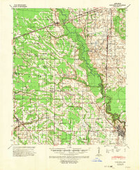
1940 Map of Marianna
USGS Topo · Published 1942About this map
The Languille River snakes through the heart of the Arkansas Delta in this 1940 survey, defining the rural landscape between Marianna and Palestine. This era in Lee County was characterized by a dense network of tenant farms and small communities, evidenced by the high concentration of neighborhood institutions like Mt Gilead Ch, Scruggs Chapel, and Holders Corners. The terrain is marked by numerous bayous and creeks, including Big Creek and Hog Tusk Creek, which shaped the agricultural layout of the region.
Find a feature on this map
57 named features on this map. Tap any name to fly to it.
Don’t see what you’re looking for? This feature index may not catch every label — zoom into the map to look around manually.
Map Details
Editions of this 1940 Marianna Map
2 editions found
Other maps of this area

1939 · Park Place
USGS Topo · 1:62,500

1939 · Wynne
USGS Topo · 1:62,500

1939 · Hunter
USGS Topo · 1:62,500

1939 · Latour
USGS Topo · 1:62,500

1940 · Marvell
USGS Topo · 1:62,500

1940 · Whitmore
USGS Topo · 1:62,500

1940 · Holly Grove
USGS Topo · 1:62,500

1940 · Brinkley
USGS Topo · 1:62,500

1948 · Helena
USGS Topo · 1:250,000

1950 · Helena
USGS Topo · 1:250,000