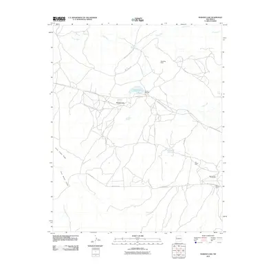
2010 Map of Mariano Lake
USGS Topo · Published 2010About this map
Mariano Lake serves as a central hub for this portion of the Eastern Navajo Agency, where the community and the Mariano Lake Dam dominate the high plateau geography. The landscape is defined by a complex network of local routes, including Navajo Service Route 11 and the winding Crystal Hill Loop, which connect the settlement to outlying areas like Standing Rock. These roads follow natural contours between prominent geological features such as Fallen Timber Ridge and the deep cut of Crazy Woman Canyon. Evidence of industrial exploration is found in the southeastern corner, where several extraction sites including Black Jack Mine Number Two, Mac Number One, and Mac Number Two are located. Water sources like Red Willow Spring and Carrizo Spring provide vital points of interest in this arid environment, while the Puerco River drainage patterns the northern reaches.
Find a feature on this map
25 named features on this map. Tap any name to fly to it.
Don’t see what you’re looking for? This feature index may not catch every label — zoom into the map to look around manually.
Map Details
Editions of this 2010 Mariano Lake Map
This is the sole edition of this map. No revisions or reprints were ever made.
Other maps of this area

1886 · Wingate
USGS Topo · 1:250,000

1892 · Wingate
USGS Topo · 1:250,000

1954 · Gallup
USGS Topo · 1:250,000

1958 · Gallup
USGS Topo · 1:250,000

1959 · Gallup
USGS Topo · 1:250,000

1962 · Gallup
USGS Topo · 1:250,000

1962 · Ciniza
USGS Topo · 1:24,000

1962 · Continental Divide
USGS Topo · 1:24,000
1963 · Hosta Butte
USGS Topo · 1:24,000
1963 · Crownpoint
USGS Topo · 1:24,000
Featured Places
- Eastern Navajo Agency, NM
- Mariano Lake, Eastern Navajo Agency
- McKinley County, NM
- United States
- New Mexico