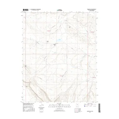
2017 Map of Mariano Lake
USGS Topo · Published 2017About this map
Mariano Lake serves as a central point in this high-elevation landscape within the Eastern Navajo Agency. The terrain is defined by dramatic landforms such as the Dutton Plateau, Fallen Timber Ridge, and the deeply etched Crazy Woman Canyon in the southwest. Settlement patterns are sparse, primarily clustered near Standing Rock and the namesake lake, connected by a network of service routes and local roads like Mariano Lake Loop and Navajo Svc Rte 49.
Find a feature on this map
30 named features on this map. Tap any name to fly to it.
Don’t see what you’re looking for? This feature index may not catch every label — zoom into the map to look around manually.
Map Details
Editions of this 2017 Mariano Lake Map
This is the sole edition of this map. No revisions or reprints were ever made.
Other maps of this area

1886 · Wingate
USGS Topo · 1:250,000

1892 · Wingate
USGS Topo · 1:250,000

1954 · Gallup
USGS Topo · 1:250,000

1958 · Gallup
USGS Topo · 1:250,000

1959 · Gallup
USGS Topo · 1:250,000

1962 · Gallup
USGS Topo · 1:250,000

1962 · Ciniza
USGS Topo · 1:24,000

1962 · Continental Divide
USGS Topo · 1:24,000
1963 · Hosta Butte
USGS Topo · 1:24,000
1963 · Crownpoint
USGS Topo · 1:24,000
Featured Places
- Eastern Navajo Agency, NM
- Mariano Lake, Eastern Navajo Agency
- McKinley County, NM
- United States
- New Mexico