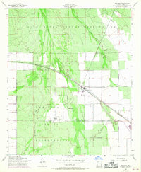
1952 Map of Maricopa
USGS Topo · Published 1968About this map
Gila River Indian Reservation and the Maricopa Indian Reservation lands converge in this mid-century topographic record, centered on the railway junction of Maricopa. The landscape is dominated by the complex drainage of the Santa Cruz Wash and Vekol Wash, set against an agricultural and industrial infrastructure including Oil & Gasoline Tanks and several Pits.
Find a feature on this map
21 named features on this map. Tap any name to fly to it.
Don’t see what you’re looking for? This feature index may not catch every label — zoom into the map to look around manually.
Map Details
Editions of this 1952 Maricopa Map
3 editions found
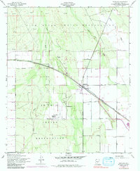
Other maps of this area

1913 · Maricopa
USGS Topo · 1:62,500

1914 · Gila Butte
USGS Topo · 1:62,500

1915 · Maricopa
USGS Topo · 1:62,500

1917 · Gila Butte
USGS Topo · 1:62,500

1922 · Casa Grande
USGS Topo · 1:62,500

1924 · Casa Grande
USGS Topo · 1:62,500

1946 · Antelope Peak
USGS Topo · 1:62,500

1948 · Antelope Peak
USGS Topo · 1:62,500

1952 · Maricopa
USGS Topo · 1:24,000

1952 · Sacaton Butte
USGS Topo · 1:24,000