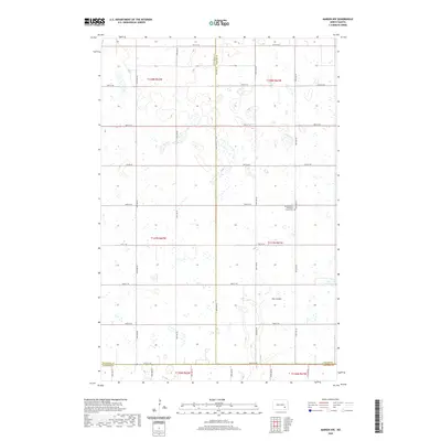
2020 Map of Marion NW
USGS Topo · Published 2020About this map
The intersection of three North Dakota counties—Stutsman, Barnes, and LaMoure—defines the southern and western reaches of this prairie landscape. The area is characterized by a high density of small wetlands and depressions typical of the Missouri Coteau region, with Dry Coulee providing a notable topographic break in the southeastern quadrant. The most significant historical landmark is the North Marion Reformed Church Cem, located near the intersection of 50th St SE and 98th Ave SE. This religious site serves as a vital anchor for family researchers and genealogists tracing the rural settlement patterns of the Meadow Lake Township area. The map illustrates a strictly rectilinear section-line road network, including Co Hwy 37, which overlays a complex natural hydrology of scattered prairie potholes.
Find a feature on this map
30 named features on this map. Tap any name to fly to it.
Don’t see what you’re looking for? This feature index may not catch every label — zoom into the map to look around manually.
Map Details
Editions of this 2020 Marion NW Map
This is the sole edition of this map. No revisions or reprints were ever made.
Other maps of this area

1896 · Jamestown
USGS Topo · 1:125,000

1897 · Eckelson
USGS Topo · 1:125,000

1952 · Ypsilanti
USGS Topo · 1:24,000

1952 · Dickey
USGS Topo · 1:24,000

1953 · Jamestown
USGS Topo · 1:250,000

1953 · Montpelier
USGS Topo · 1:24,000

1953 · Adrian
USGS Topo · 1:24,000

1956 · Jamestown
USGS Topo · 1:250,000

1970 · Marion NE
USGS Topo · 1:24,000
1970 · Marion NW
USGS Topo · 1:24,000
Featured Places
- Meadow Lake Township, ND
- Greenland Township, ND
- Saratoga Township, ND
- Sheridan Township, ND
- Stutsman County, ND