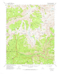
1967 Map of Marion Peak
USGS Topo · Published 1973About this map
Kings Canyon National Park dominates this high-altitude survey, showcasing a landscape defined by the deep glacial carving of the Middle Fork Kings River and the South Fork Kings River. The terrain transitions from the floor of the Kings Canyon at Cedar Grove up to the towering heights of Marion Peak and the Cirque Crest. This 1967 revision captures the primitive character of the Sierra Nevada wilderness before modern high-impact recreation, marking the historic Muir Trail as it traverses the White Divide and descends toward Simpson Meadow. Notable landmarks for backcountry historians include the Kanawyers (Site), representing an era of early mountain hospitality, and evocatively named features like the Gorge of Despair and Lake of the Fallen Moon. The map meticulously tracks the intricate network of alpine drainage, from Blue Canyon Falls to the sprawling Lake Basin, illustrating the hydrographic complexity of the Fresno County highlands.
Find a feature on this map
128 named features on this map. Tap any name to fly to it.
Don’t see what you’re looking for? This feature index may not catch every label — zoom into the map to look around manually.
Map Details
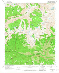
Editions of this 1967 Marion Peak Map
2 editions found
Other maps of this area

1903 · Tehipite
USGS Topo · 1:125,000

1905 · Tehipite
USGS Topo · 1:125,000

1907 · Mt. Whitney
USGS Topo · 1:125,000

1912 · Mt. Goddard
USGS Topo · 1:125,000

1913 · Bishop
USGS Topo · 1:125,000

1919 · Mt. Whitney
USGS Topo · 1:125,000

1937 · Mt. Whitney
USGS Topo · 1:125,000

1947 · Mariposa
USGS Topo · 1:250,000

1948 · Fresno
USGS Topo · 1:250,000

1948 · Mariposa
USGS Topo · 1:250,000