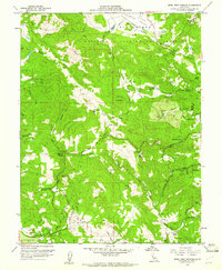
1958 Map of Mark West Springs
USGS Topo · Published 1961About this map
Petrified Forest stands as a primary landmark in this late 1950s survey of the hills between Santa Rosa and the Napa Valley line. The map highlights a landscape of historical ranching and small-scale settlement, anchored by Mark West Springs and the nearby Mark West Creek Rancheria. Ancient Spanish land grants still leave their mark through labels like Moristul y Plan de Agua Caliente and Carne Humana, reflecting the complex property history of the region. The drainage patterns of Mark West Creek and Franz Creek define the topography, while rural education centers like the Alpine School and routes such as Franz Valley School Road indicate the established community structure. From the small settlement of Fulton to the varied heights of Chalk Mtn and Sugarloaf, this map documents a era of rural Sonoma County before modern suburban expansion.
Find a feature on this map
45 named features on this map. Tap any name to fly to it.
Don’t see what you’re looking for? This feature index may not catch every label — zoom into the map to look around manually.
Map Details
Editions of this 1958 Mark West Springs Map
3 editions found
Other maps of this area

1916 · Santa Rosa
USGS Topo · 1:62,500

1920 · Healdsburg
USGS Topo · 1:62,500

1927 · Calistoga
USGS Topo · 1:62,500

1933 · Healdsburg
USGS Topo · 1:48,000

1935 · Sebastopol
USGS Topo · 1:48,000

1940 · Healdsburg
USGS Topo · 1:62,500

1942 · Sebastopol
USGS Topo · 1:62,500

1943 · Calistoga
USGS Topo · 1:62,500

1944 · Santa Rosa
USGS Topo · 1:62,500

1945 · Calistoga
USGS Topo · 1:62,500