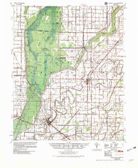
1956 Map of Marked Tree
USGS Topo · Published 1956About this map
The St Francis Sunk Lands dominate this mid-century landscape, illustrating the complex hydrology of the St Francis River basin. Following the flood control work of the early 1950s, the map reveals a highly engineered environment of levees and siphons designed to manage the water of the Little River and its various chutes. Local history and social life are anchored by landmarks like the Hatchie Coon Hunting Lodge and the Oak Donnick Club House, while industry is represented by the presence of Fry's Mill and Dewey Mill. The rail networks of the St Louis Southwestern and St Louis San Francisco connect the larger hubs of Marked Tree and Lepanto to smaller siding settlements like Tulot and Rivervale. Notable for genealogists, the sheet documents numerous country churches and burial sites, including the Nichols Cem and Rock of Ages Ch & Cent.
Find a feature on this map
67 named features on this map. Tap any name to fly to it.
Don’t see what you’re looking for? This feature index may not catch every label — zoom into the map to look around manually.
Map Details
Editions of this 1956 Marked Tree Map
2 editions found

Other maps of this area

1931 · Jericho
USGS Topo · 1:62,500

1939 · Jericho
USGS Topo · 1:62,500

1939 · Jonesboro
USGS Topo · 1:62,500

1939 · Evadale
USGS Topo · 1:62,500

1940 · Deckerville
USGS Topo · 1:62,500

1940 · Princedale
USGS Topo · 1:62,500

1940 · Dee
USGS Topo · 1:62,500

1941 · Leachville
USGS Topo · 1:62,500

1941 · Manila
USGS Topo · 1:62,500

1941 · Marked Tree
USGS Topo · 1:62,500