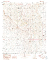
1989 Map of Markham Creek
USGS Topo · Published 1990About this map
San Carlos Indian Reservation land defines the northern and eastern reaches of this high-elevation terrain, where water sources were critical for ranching and survival. The map highlights a network of remote springs and tanks, such as Bull Springs, Angel Trail Spring, and Hot Springs Tank, providing insights into how this arid landscape was navigated and utilized in the late 20th century. Named landmarks like Slaughter Mountain and Table Mountain anchor the topography, while a series of deep drainage systems like Markham Creek, Lopas Canyon, and Brasswell Canyon carve through the earth. Evidence of land management is found at Lopas Windmill and various 4WD tracks, showing the intersection of traditional reservation boundaries with established infrastructure. This document serves as a clear record of the area's hydrology and land use before many such remote points of interest were altered by modern environmental changes.
Find a feature on this map
44 named features on this map. Tap any name to fly to it.
Don’t see what you’re looking for? This feature index may not catch every label — zoom into the map to look around manually.
Map Details
Editions of this 1989 Markham Creek Map
This is the sole edition of this map. No revisions or reprints were ever made.
Other maps of this area

1954 · Silver City
USGS Topo · 1:250,000

1954 · Clifton
USGS Topo · 1:250,000

1957 · Clifton
USGS Topo · 1:250,000

1958 · Silver City
USGS Topo · 1:250,000

1958 · Clifton
USGS Topo · 1:250,000

1960 · Thatcher
USGS Topo · 1:62,500

1960 · Fort Thomas
USGS Topo · 1:62,500

1960 · Safford
USGS Topo · 1:62,500

1962 · Silver City
USGS Topo · 1:250,000

1962 · Clifton
USGS Topo · 1:250,000