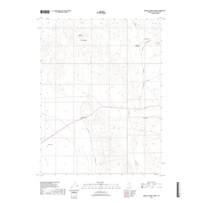
2018 Map of Marking Corral Summit
USGS Topo · Published 2018About this map
Marking Corral Summit stands as a prominent high point between the Butte Mountains and the northern reaches of Jakes Valley in this remote section of White Pine County. The landscape is defined by its arid drainage patterns and an established network of primitive roads that connect isolated points across the high desert terrain. Water is a scarce and vital resource here, marked by the presence of Summit Spring and the drainage of Illipah Cr at the southern edge of the survey. The infrastructure is primarily composed of county thoroughfares and access routes such as Thirtymile Rd and Jakes Wash Rd, which follow the natural contours of the valley floors and mountain passes. This survey provides a precise look at the topographical relationship between the varying elevations of the Butte Mountains and the vast basin of Jakes Valley before the modernization of rural transport.
Find a feature on this map
16 named features on this map. Tap any name to fly to it.
Don’t see what you’re looking for? This feature index may not catch every label — zoom into the map to look around manually.
Map Details
Editions of this 2018 Marking Corral Summit Map
This is the sole edition of this map. No revisions or reprints were ever made.
Other maps of this area

1951 · Illipah
USGS Topo · 1:62,500

1956 · Ely
USGS Topo · 1:250,000

1958 · Reipetown
USGS Topo · 1:24,000

1959 · Ely
USGS Topo · 1:250,000

1959 · Reipetown
USGS Topo · 1:62,500

1963 · Ely
USGS Topo · 1:250,000

1979 · Mt. Hamilton
USGS Topo · 1:100,000

1982 · Dickenson Well
USGS Topo · 1:24,000
1982 · Thirtymile Ranch
USGS Topo · 1:24,000
1982 · Combs Creek
USGS Topo · 1:24,000