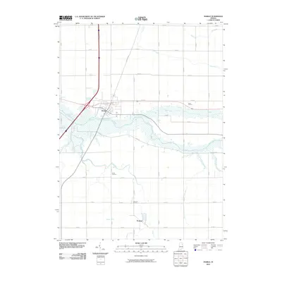
2010 Map of Markle
USGS Topo · Published 2010About this map
Markle and the smaller settlement of Rockford sit at the heart of this Wells County landscape, where the Wabash River meanders through a network of agricultural drainage systems. The map illustrates a highly managed hydrological environment, defined by named watercourses like Griffin Ditch, Redding Ditch, and Lesh Ditch that support the surrounding farm tracts. Significant genealogical landmarks are preserved across the quadrangle, including the centrally located Sparks Cemetery near Rock Creek, and Horeb Cemetery to the east. The intersection of modern infrastructure and traditional land divisions is evident in the grid of local roads, such as W Oak Rd and N Marzane Rd, which connect these rural communities and historical burial grounds.
Find a feature on this map
43 named features on this map. Tap any name to fly to it.
Don’t see what you’re looking for? This feature index may not catch every label — zoom into the map to look around manually.
Map Details
Editions of this 2010 Markle Map
This is the sole edition of this map. No revisions or reprints were ever made.
Other maps of this area

1950 · Warren
USGS Topo · 1:24,000

1952 · Warren
USGS Topo · 1:24,000

1952 · Majenica
USGS Topo · 1:24,000

1953 · Muncie
USGS Topo · 1:250,000

1955 · Markle
USGS Topo · 1:24,000

1956 · Muncie
USGS Topo · 1:250,000

1956 · Huntington
USGS Topo · 1:24,000
1961 · Zanesville
USGS Topo · 1:24,000

1962 · Uniondale
USGS Topo · 1:24,000

1962 · Ossian
USGS Topo · 1:24,000