
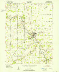
1952 Map of Warren
USGS Topo · Published 1952About this map
The Salamonie River winds through the heart of this mid-century landscape, anchoring the town of Warren where the New York Chicago and St Louis railroad intersects with the local road network. The map reveals a transition between rural townships such as Salamonie, Jefferson, and Rock Creek, which are dotted with small family-named burial grounds including Taylor Cem and West Union Cem. A notable localized landmark is the Water Methodist Home situated near the town center.
Find a feature on this map
25 named features on this map. Tap any name to fly to it.
Don’t see what you’re looking for? This feature index may not catch every label — zoom into the map to look around manually.
Map Details
Editions of this 1952 Warren Map
2 editions found
Other maps of this area

1950 · Andrews
USGS Topo · 1:24,000

1950 · Warren
USGS Topo · 1:24,000

1950 · Mount Etna
USGS Topo · 1:24,000

1951 · Mount Etna
USGS Topo · 1:24,000

1951 · Andrews
USGS Topo · 1:24,000

1952 · Majenica
USGS Topo · 1:24,000

1953 · Muncie
USGS Topo · 1:250,000

1955 · Markle
USGS Topo · 1:24,000

1956 · Muncie
USGS Topo · 1:250,000

1962 · Montpelier
USGS Topo · 1:24,000