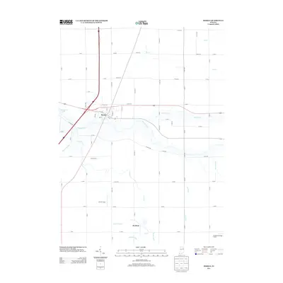
2013 Map of Markle
USGS Topo · Published 2013About this map
The Wabash River carves through the heart of this landscape, anchoring the town of Markle near the junction of several critical regional transit corridors. This 2013 survey illustrates the local agricultural and drainage infrastructure, defined by an intricate network of man-made waterways like Griffin Ditch, Redding Ditch, and Lesh Ditch that feed into natural streams such as Rock Cr. To the south, the small community of Rockford and the established Worster Farms signify the area's rural character, while the presence of Johnson Airport and Grandlienard-Hogg Airport highlights the importance of light aviation to the local economy. The western edge of the quadrangle is marked by the waters of Huntington Lake, indicating the scale of water management and recreation at the county border.
Find a feature on this map
46 named features on this map. Tap any name to fly to it.
Don’t see what you’re looking for? This feature index may not catch every label — zoom into the map to look around manually.
Map Details
Editions of this 2013 Markle Map
This is the sole edition of this map. No revisions or reprints were ever made.
Other maps of this area

1950 · Warren
USGS Topo · 1:24,000

1952 · Warren
USGS Topo · 1:24,000

1952 · Majenica
USGS Topo · 1:24,000

1953 · Muncie
USGS Topo · 1:250,000

1955 · Markle
USGS Topo · 1:24,000

1956 · Muncie
USGS Topo · 1:250,000

1956 · Huntington
USGS Topo · 1:24,000
1961 · Zanesville
USGS Topo · 1:24,000

1962 · Uniondale
USGS Topo · 1:24,000

1962 · Ossian
USGS Topo · 1:24,000