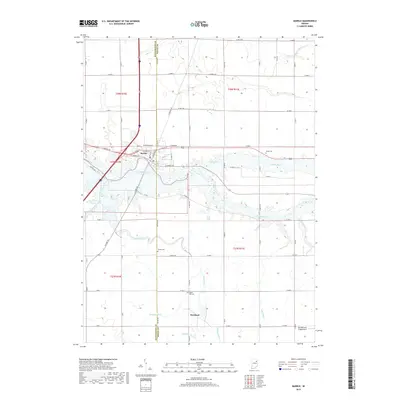
2019 Map of Markle
USGS Topo · Published 2019About this map
Wabash River meanders across the Huntington and Wells county line, anchoring the town of Markle near its northern banks. The landscape is defined by an extensive drainage network, including Griffin Ditch and Rock Creek, which supported the agricultural development of this northern Indiana region. To the south, the small settlement of Rockford is situated near the confluence of Redding Ditch and Whitelock Ditch, illustrating how early infrastructure was tied to these watercourses. Genealogists will find several burial grounds of interest, such as Horeb Cem and Sparks Cem, alongside the uniquely named Spider Hill Cem. The southern edge of the survey also includes the Grandlienard-Hogg Airport, reflecting the blend of rural legacy and modern utility in this river valley.
Find a feature on this map
54 named features on this map. Tap any name to fly to it.
Don’t see what you’re looking for? This feature index may not catch every label — zoom into the map to look around manually.
Map Details
Editions of this 2019 Markle Map
This is the sole edition of this map. No revisions or reprints were ever made.
Other maps of this area

1950 · Warren
USGS Topo · 1:24,000

1952 · Warren
USGS Topo · 1:24,000

1952 · Majenica
USGS Topo · 1:24,000

1953 · Muncie
USGS Topo · 1:250,000

1955 · Markle
USGS Topo · 1:24,000

1956 · Muncie
USGS Topo · 1:250,000

1956 · Huntington
USGS Topo · 1:24,000
1961 · Zanesville
USGS Topo · 1:24,000

1962 · Uniondale
USGS Topo · 1:24,000

1962 · Ossian
USGS Topo · 1:24,000