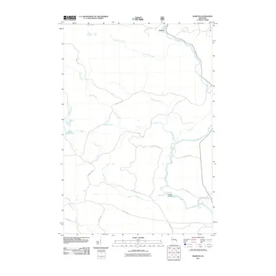
2011 Map of Markton
USGS Topo · Published 2011About this map
The Wolf River defines the landscape of this northern Wisconsin quadrangle, joined by a dense network of tributaries including Evergreen River, McCall Creek, and Burnt Shanty Creek. This 2011 survey captures a region primarily shaped by its waterways and timber history, with the small settlement of Markton situated in the northern reaches near the riverbanks. The terrain is marked by numerous cascades, such as Evergreen Falls, Sullivan Falls, and Big Smoky Falls, indicating the elevation changes that drive the local hydrography.
Find a feature on this map
31 named features on this map. Tap any name to fly to it.
Don’t see what you’re looking for? This feature index may not catch every label — zoom into the map to look around manually.
Map Details
Editions of this 2011 Markton Map
This is the sole edition of this map. No revisions or reprints were ever made.
Other maps of this area

1952 · White Lake
USGS Topo · 1:48,000

1952 · Langlade
USGS Topo · 1:48,000

1954 · Gresham
USGS Topo · 1:48,000

1954 · Shawano
USGS Topo · 1:48,000

1954 · Iron Mountain
USGS Topo · 1:250,000

1955 · Green Bay
USGS Topo · 1:250,000

1959 · Iron Mountain
USGS Topo · 1:250,000

1964 · Shawano
USGS Topo · 1:62,500

1964 · Gresham
USGS Topo · 1:62,500
1973 · Langlade
USGS Topo · 1:24,000