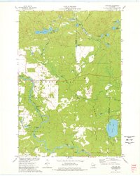
1973 Map of Langlade
USGS Topo · Published 1977About this map
The Wolf River defines the western landscape of this Wisconsin region, marked by a series of turbulent water features including Larzelere Rapids, Crowle Rapids, and Horse Race Rapids. The small settlement of Langlade serves as a local hub near the St Stanislaus Ch and an adjacent Cem, reflecting the rural community life of the early 1970s. This area is heavily defined by conservation and recreation, with significant acreage dedicated to the Nicolet National Forest and the Wolf River State Fishery Area.
Find a feature on this map
54 named features on this map. Tap any name to fly to it.
Don’t see what you’re looking for? This feature index may not catch every label — zoom into the map to look around manually.
Map Details
Editions of this 1973 Langlade Map
2 editions found
Other maps of this area

1942 · Wabeno
USGS Topo · 1:48,000

1942 · Pearson
USGS Topo · 1:48,000

1950 · Wabeno
USGS Topo · 1:48,000

1950 · Lily
USGS Topo · 1:48,000

1951 · Wabeno
USGS Topo · 1:48,000

1952 · White Lake
USGS Topo · 1:48,000

1952 · Langlade
USGS Topo · 1:48,000

1954 · Iron Mountain
USGS Topo · 1:250,000

1959 · Iron Mountain
USGS Topo · 1:250,000
1972 · Townsend
USGS Topo · 1:24,000