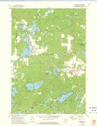
1972 Map of Townsend
USGS Topo · Published 1975About this map
Townsend and Lakewood serve as the primary human anchors in this 1970s landscape, which is heavily defined by the dense woodlands of the Nicolet National Forest. The Chicago and North Western railroad provides the industrial spine of the region, cutting a path through the timber toward the northern border. This era shows a complex hydrologic network, with the sprawling Townsend Flowage and numerous named water bodies like Archibald Lake and Pickerel Lake shaping the local geography. Local history is evidenced at Forest Home Cem and the Lakewood State Fish Hatchery. The presence of the Archibald Lookout Tower and nearby Archibald Tower Springs highlights the fire-prevention infrastructure essential to this forested district in the Oconto County highlands. The map provides a look at the relationship between recreation, conservation, and resource extraction, with scattered Gravel Pits and public access points along the North Branch Oconto River.
Find a feature on this map
66 named features on this map. Tap any name to fly to it.
Don’t see what you’re looking for? This feature index may not catch every label — zoom into the map to look around manually.
Map Details
Editions of this 1972 Townsend Map
2 editions found
Other maps of this area

1940 · Thunder Mtn.
USGS Topo · 1:48,000

1942 · Breed
USGS Topo · 1:48,000

1942 · Wabeno
USGS Topo · 1:48,000

1950 · Wabeno
USGS Topo · 1:48,000

1951 · Wabeno
USGS Topo · 1:48,000

1951 · Thunder Mountain
USGS Topo · 1:48,000

1952 · Langlade
USGS Topo · 1:48,000

1952 · Mountain
USGS Topo · 1:48,000

1954 · Iron Mountain
USGS Topo · 1:250,000

1959 · Iron Mountain
USGS Topo · 1:250,000