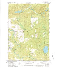
1973 Map of Langlade
USGS Topo · Published 1984About this map
The Wolf River defines the landscape of this region on the Langlade and Oconto county line during the early 1970s. The river is marked by a series of significant whitewater features including Larzelere Rapids, Crowle Rapids, and Twenty Day Rapids. Much of the eastern portion of the map is dominated by the Nicolet National Forest, while the river corridor itself is preserved within the Wolf River State Fishery Area. The small settlement of Langlade serves as a local hub, featuring St Stanislaus Ch and a nearby Cem. Evidence of the area's industrial past is visible in the Old Railroad Grade and an active Soo Line segment, while recreational land use is prominent at Boulder Lake Campground and the Gardner Dam Camp situated near Hanson Rapids.
Find a feature on this map
54 named features on this map. Tap any name to fly to it.
Don’t see what you’re looking for? This feature index may not catch every label — zoom into the map to look around manually.
Map Details
Editions of this 1973 Langlade Map
2 editions found
Other maps of this area

1942 · Wabeno
USGS Topo · 1:48,000

1942 · Pearson
USGS Topo · 1:48,000

1950 · Wabeno
USGS Topo · 1:48,000

1950 · Lily
USGS Topo · 1:48,000

1951 · Wabeno
USGS Topo · 1:48,000

1952 · White Lake
USGS Topo · 1:48,000

1952 · Langlade
USGS Topo · 1:48,000

1954 · Iron Mountain
USGS Topo · 1:250,000

1959 · Iron Mountain
USGS Topo · 1:250,000
1972 · Townsend
USGS Topo · 1:24,000