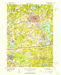
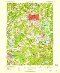
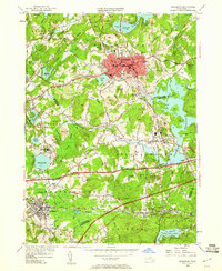
1953 Map of Marlboro
USGS Topo · Published 1955About this map
The manufacturing and agricultural landscape of central Massachusetts is defined by a dense network of transit and industry in this mid-century survey. Marlboro serves as the primary urban hub, anchored by institutional landmarks like the Marlboro Hospital and the busy Marlboro Junction where regional rail lines intersect. The map illustrates a complex water management system featuring the Fort Meadow Reservoir, Millham Reservoir, and Chauncy Lake, which shaped the development of surrounding towns like Southboro and Westboro.
Find a feature on this map
95 named features on this map. Tap any name to fly to it.
Don’t see what you’re looking for? This feature index may not catch every label — zoom into the map to look around manually.
Map Details
Editions of this 1953 Marlboro Map
4 editions found

Other maps of this area

1886 · Blackstone
USGS Topo · 1:62,500

1886 · Framingham
USGS Topo · 1:62,500

1887 · Franklin
USGS Topo · 1:62,500

1887 · Marlboro
USGS Topo · 1:62,500

1889 · Marlboro
USGS Topo · 1:62,500

1889 · Blackstone
USGS Topo · 1:62,500

1889 · Franklin
USGS Topo · 1:62,500

1889 · Framingham
USGS Topo · 1:62,500

1893 · Franklin
USGS Topo · 1:62,500

1893 · Blackstone
USGS Topo · 1:62,500