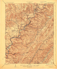
1925 Map of Marlinton
USGS Topo · Published 1925About this map
Marlinton serves as the focal point of this 1920s survey, situated at the confluence of Knapp Creek and the Greenbrier River. The landscape is defined by the sharp contrast between the elevated Black Mts and the agricultural pocket of the Little Levels, where the settlement of Hillsboro is established. This era captures the vital role of the Chesapeake and Ohio RR as it snakes along the riverbank, connecting timber and coal outposts like Seebert, Watoga, and Denmark.
Find a feature on this map
130 named features on this map. Tap any name to fly to it.
Don’t see what you’re looking for? This feature index may not catch every label — zoom into the map to look around manually.
Map Details
Editions of this 1925 Marlinton Map
3 editions found

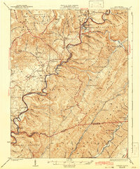
Other maps of this area

1887 · Lewisburg
USGS Topo · 1:125,000

1891 · Lewisburg
USGS Topo · 1:125,000

1891 · Huntersville
USGS Topo · 1:125,000

1894 · Huntersville
USGS Topo · 1:125,000

1894 · Natural Bridge
USGS Topo · 1:125,000

1901 · Monterey
USGS Topo · 1:125,000

1915 · Webster Springs
USGS Topo · 1:48,000

1918 · Webster Springs
USGS Topo · 1:62,500

1921 · Callaghan
USGS Topo · 1:48,000

1921 · White Sulphur Springs
USGS Topo · 1:48,000