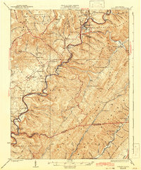
1925 Map of Marlinton
USGS Topo · Published 1942About this map
The Greenbrier River carves a deep valley through the center of this Pocahontas County landscape, serving as the primary corridor for the Chesa and Ohio RR. Along this rail line, the county seat of Marlinton stands as a vital hub, supported by smaller settlements like Buckeye and Seebert. The map illustrates a region transitioning between upland forest and valley agriculture, with the western reaches of the Monongahela National Forest covering the heights of the Black Mountains and Cranberry Mountains.
Find a feature on this map
117 named features on this map. Tap any name to fly to it.
Don’t see what you’re looking for? This feature index may not catch every label — zoom into the map to look around manually.
Map Details
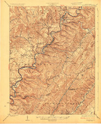
Editions of this 1925 Marlinton Map
3 editions found

Other maps of this area

1887 · Lewisburg
USGS Topo · 1:125,000

1891 · Lewisburg
USGS Topo · 1:125,000

1891 · Huntersville
USGS Topo · 1:125,000

1894 · Huntersville
USGS Topo · 1:125,000

1894 · Natural Bridge
USGS Topo · 1:125,000

1901 · Monterey
USGS Topo · 1:125,000

1915 · Webster Springs
USGS Topo · 1:48,000

1918 · Webster Springs
USGS Topo · 1:62,500

1921 · Callaghan
USGS Topo · 1:48,000

1921 · White Sulphur Springs
USGS Topo · 1:48,000