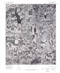
1975 Map of Marlow SE
USGS Topo · Published 1976About this map
Chisholm Trail Lake serves as a prominent landmark in this section of Stephens County, reflecting the region's historical connection to the legendary cattle driving route that once crossed the Oklahoma territory. This orthophotoquad, derived from 1975 aerial photography, provides a rare visual record of the landscape's agricultural character and hydrological features during the mid-1970s. The meandering course of Wildhorse Creek cuts through the terrain, illustrating the natural drainage patterns that have shaped local ranching and farming practices for generations. The aerial perspective captures the distinct patchwork of field boundaries and drainage basins, offering researchers a literal view of the land as it appeared before decades of modern development and changing land-use patterns altered the rural Oklahoma countryside.
Find a feature on this map
2 named features on this map. Tap any name to fly to it.
Don’t see what you’re looking for? This feature index may not catch every label — zoom into the map to look around manually.
Map Details
Editions of this 1975 Marlow SE Map
This is the sole edition of this map. No revisions or reprints were ever made.
Other maps of this area

1901 · Addington
USGS Topo · 1:125,000

1902 · Rush Springs
USGS Topo · 1:125,000

1950 · Marlow
USGS Topo · 1:62,500

1951 · Marlow
USGS Topo · 1:62,500

1957 · Ardmore
USGS Topo · 1:250,000

1963 · Ardmore
USGS Topo · 1:250,000

1963 · Harrisburg
USGS Topo · 1:24,000

1964 · Duncan South
USGS Topo · 1:24,000
1974 · Cox City
USGS Topo · 1:24,000
1974 · Velma
USGS Topo · 1:24,000