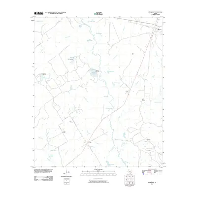
2010 Map of Marquez
USGS Topo · Published 2010About this map
The Navasota River meanders through this portion of Leon County, defining a landscape of wetlands, sloughs, and drainage basins. Small settlements and rural hubs such as Marquez, Ridge, and Venetia are connected by a network of county roads, including Old River Rd and Grassy Lake Rd. The area is characterized by numerous small water bodies and impoundments like Wolf Lake, Artesian Lake, and Antelope Lake, which suggest a history of local water management for agriculture or ranching. Genealogists will find significant value in the documentation of several local burial grounds, including Winn Cemetery, Holly Cemetery, and Kaster Cemetery. The terrain is marked by subtle rises such as Payne Hill, while creeks like Steele Creek and Red Oak Creek feed into the broader river system, illustrating the hydrology of east-central Texas during this period.
Find a feature on this map
56 named features on this map. Tap any name to fly to it.
Don’t see what you’re looking for? This feature index may not catch every label — zoom into the map to look around manually.
Map Details
Editions of this 2010 Marquez Map
This is the sole edition of this map. No revisions or reprints were ever made.
Other maps of this area

1925 · Marquez No. 1
USGS Topo · 1:48,000

1925 · Marquez No. 4
USGS Topo · 1:48,000

1927 · Marquez
USGS Topo · 1:62,500

1930 · Marquez
USGS Topo · 1:62,500

1954 · Waco
USGS Topo · 1:250,000

1955 · Waco
USGS Topo · 1:250,000

1956 · Jewett
USGS Topo · 1:62,500
1964 · Hilltop Lakes
USGS Topo · 1:24,000

1964 · Margie
USGS Topo · 1:24,000

1965 · Jewett
USGS Topo · 1:24,000