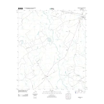
2013 Map of Marquez
USGS Topo · Published 2013About this map
The Navasota River meanders through the central corridor of this Leon County landscape, defining a terrain of numerous sloughs and lakes. The settlement of Marquez sits in the northeast corner at the intersection of Barkley Rd and S Old Flynn Rd, while smaller communities like Ridge and Venetia are situated to the south. This area is characterized by its agricultural and ranching layout, indicated by landmarks such as Camp Cooley Ranch Rd and numerous family or local burial sites including Winn Cem and Bateman Cem.
Find a feature on this map
74 named features on this map. Tap any name to fly to it.
Don’t see what you’re looking for? This feature index may not catch every label — zoom into the map to look around manually.
Map Details
Editions of this 2013 Marquez Map
This is the sole edition of this map. No revisions or reprints were ever made.
Other maps of this area

1925 · Marquez No. 1
USGS Topo · 1:48,000

1925 · Marquez No. 4
USGS Topo · 1:48,000

1927 · Marquez
USGS Topo · 1:62,500

1930 · Marquez
USGS Topo · 1:62,500

1954 · Waco
USGS Topo · 1:250,000

1955 · Waco
USGS Topo · 1:250,000

1956 · Jewett
USGS Topo · 1:62,500
1964 · Hilltop Lakes
USGS Topo · 1:24,000

1964 · Margie
USGS Topo · 1:24,000

1965 · Jewett
USGS Topo · 1:24,000