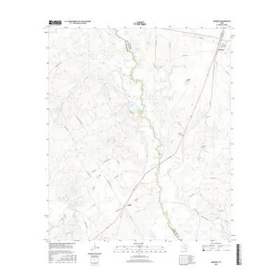
2016 Map of Marquez
USGS Topo · Published 2016About this map
The Navasota River forms a wide, swampy corridor through the center of this landscape, marking the boundary between Robertson and Leon counties. This river valley is a complex network of seasonal wetlands and oxbow formations including Bear Rough Lake, Artesian Lake, and Grassy Lake. On the eastern side of the bottomlands, the community of Marquez serves as a local hub near the intersection of V W Goodwin Blvd and S Commerce St. The surrounding uplands, such as Payne Hill, are dotted with several small burial grounds that speak to the area's rural settlement history, including Winn Cem, Bateman Cem, and Brushy Cem. To the southwest, the small settlement of Ridge sits at a crossroads, surrounded by numerous named ponds and creek branches like Red Oak Cr and Lake Branch, illustrating a terrain defined by its intricate drainage patterns and agricultural homesteads.
Find a feature on this map
70 named features on this map. Tap any name to fly to it.
Don’t see what you’re looking for? This feature index may not catch every label — zoom into the map to look around manually.
Map Details
Editions of this 2016 Marquez Map
This is the sole edition of this map. No revisions or reprints were ever made.
Other maps of this area

1925 · Marquez No. 1
USGS Topo · 1:48,000

1925 · Marquez No. 4
USGS Topo · 1:48,000

1927 · Marquez
USGS Topo · 1:62,500

1930 · Marquez
USGS Topo · 1:62,500

1954 · Waco
USGS Topo · 1:250,000

1955 · Waco
USGS Topo · 1:250,000

1956 · Jewett
USGS Topo · 1:62,500
1964 · Hilltop Lakes
USGS Topo · 1:24,000

1964 · Margie
USGS Topo · 1:24,000

1965 · Jewett
USGS Topo · 1:24,000