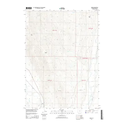
2015 Map of Marse
USGS Topo · Published 2015About this map
The Narrows forms a dramatic topographical bottleneck in the southwestern corner of this Lincoln County survey, where the Bear River winds through the landscape. This area is defined by the high elevations of the Sublette Range and Muddy Ridge, separated by a complex network of drainages including Chalk Cr and Mill Cr. The agricultural history of the region is evident in the elaborate system of irrigation canals along the eastern edge, specifically the Stoner Nelson Wheelock Ditch, Emelle Ditch, and Perry and Rocklage Ditch that follow the course of the Smiths Fork. The small settlement of Marse sits near the river, positioned between the rising canyon walls of Birch Gulch and Groo Canyon.
Find a feature on this map
30 named features on this map. Tap any name to fly to it.
Don’t see what you’re looking for? This feature index may not catch every label — zoom into the map to look around manually.
Map Details
Editions of this 2015 Marse Map
This is the sole edition of this map. No revisions or reprints were ever made.
Other maps of this area

1909 · Montpelier
USGS Topo · 1:125,000

1911 · Montpelier
USGS Topo · 1:125,000

1936 · Cokeville
USGS Topo · 1:96,000

1942 · Cokeville
USGS Topo · 1:125,000

1955 · Preston
USGS Topo · 1:250,000

1958 · Preston
USGS Topo · 1:250,000

1962 · Preston
USGS Topo · 1:250,000

1967 · Big Park
USGS Topo · 1:24,000

1967 · Huff Lake
USGS Topo · 1:24,000
1967 · Sublette Canyon
USGS Topo · 1:24,000