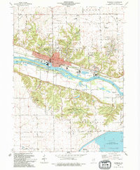
1994 Map of Marseilles
USGS Topo · Published 1994About this map
The industrial and riverfront character of Marseilles dominates this LaSalle County landscape, where the Illinois River corridor meets a complex history of transportation and power generation. The Illinois and Michigan Canal (Abandoned) and its namesake State Trail follow the northern bank, passing landmark infrastructure like the Marseilles Dam, the Gaging Sta, and Bells Island. South of the river, the terrain rises toward the expansive Marseilles State Fish and Wildlife Area and Illinois National Guard Training Area, while the LaSalle County Nuclear Station and the cooling reservoir of La Salle Lake mark the southern reach of the quadrangle.
Find a feature on this map
62 named features on this map. Tap any name to fly to it.
Don’t see what you’re looking for? This feature index may not catch every label — zoom into the map to look around manually.
Map Details
Editions of this 1994 Marseilles Map
This is the sole edition of this map. No revisions or reprints were ever made.
Other maps of this area

1892 · Marseilles
USGS Topo · 1:62,500

1892 · Ottawa
USGS Topo · 1:62,500

1915 · Ottawa
USGS Topo · 1:62,500

1916 · Marseilles
USGS Topo · 1:62,500

1925 · Streator
USGS Topo · 1:62,500

1927 · Streator
USGS Topo · 1:62,500

1940 · Marseilles
USGS Topo · 1:62,500

1946 · Ottawa
USGS Topo · 1:62,500

1958 · Odell
USGS Topo · 1:62,500

1958 · Aurora
USGS Topo · 1:250,000