1967 Map of Marsh
USGS Topo · Published 1985About this map
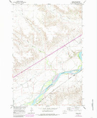
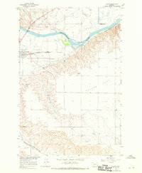
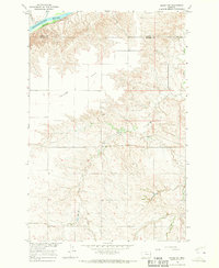
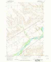
The Yellowstone River cuts a wide path through this Dawson County landscape, its banks defined by the irrigation infrastructure of the Main Canal. The small community of Marsh sits south of the river, anchored by the Burlington Northern railroad corridor and a local Cem. The map reveals an agrarian economy dependent on water management, with features like a Grain Bin and the Yale Sch marking the rural social and industrial geography of the mid-20th century. High bluffs and dissected coulees rise away from the river valley, drained by a network of seasonal waterways including Little Cracker Box Creek, Cracker Box Creek, and Clear Creek. The inclusion of a large Pipeline and the Bad Route Cr indicates the transition from traditional valley farming to modern utility and transport corridors in this portion of eastern Montana.
Find a feature on this map
13 named features on this map. Tap any name to fly to it.
Don’t see what you’re looking for? This feature index may not catch every label — zoom into the map to look around manually.
Map Details
Editions of this 1967 Marsh Map
2 editions found
Other maps of this area

1909 · Glendive
USGS Topo · 1:250,000

1953 · Miles City
USGS Topo · 1:250,000

1954 · Glendive
USGS Topo · 1:250,000

1957 · Miles City
USGS Topo · 1:250,000

1957 · Glendive
USGS Topo · 1:250,000

1958 · Miles City
USGS Topo · 1:250,000

1958 · Glendive
USGS Topo · 1:250,000
1966 · Fallon
USGS Topo · 1:24,000
1966 · Marsh SW
USGS Topo · 1:24,000
1967 · Marsh
USGS Topo · 1:24,000