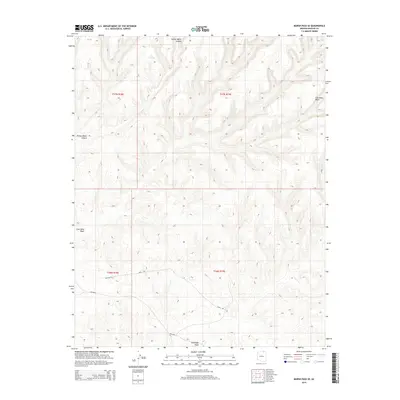
2014 Map of Marsh Pass SE
USGS Topo · Published 2014About this map
Moenkopi Wash and Coal Mine Wash carve through this high-desert landscape in Navajo County, revealing a drainage pattern that has defined the region's geography. The map shows a transition from the deep relief of Yellow Water Canyon in the north to the more open basins near the southern boundary. Infrastructure is sparse, characterized primarily by local routes such as Main Rd and Haulage Rd, which suggest the movement of resources or equipment through the remote terrain. A vital water point, Pine Spring, is situated near the head of a drainage in the northern section, marking a rare reliable water source in this arid environment. The presence of Bia-8034 reflects the involvement of the Bureau of Indian Affairs in maintaining the transport network within the reservation lands of this quadrangle.
Find a feature on this map
11 named features on this map. Tap any name to fly to it.
Don’t see what you’re looking for? This feature index may not catch every label — zoom into the map to look around manually.
Map Details
Editions of this 2014 Marsh Pass SE Map
This is the sole edition of this map. No revisions or reprints were ever made.
Other maps of this area

1883 · Marsh Pass
USGS Topo · 1:250,000

1892 · Marsh Pass
USGS Topo · 1:250,000

1956 · Marble Canyon
USGS Topo · 1:250,000

1959 · Marble Canyon
USGS Topo · 1:250,000

1961 · Marble Canyon
USGS Topo · 1:250,000
1968 · Kayenta East
USGS Topo · 1:24,000
1968 · Kayenta West
USGS Topo · 1:24,000

1968 · Marsh Pass
USGS Topo · 1:24,000
1968 · Owl Spring
USGS Topo · 1:24,000

1968 · Yucca Hill
USGS Topo · 1:24,000