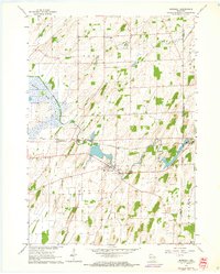
1962 Map of Marshall
USGS Topo · Published 1964About this map
The Maunesha River winds through the heart of the Wisconsin countryside, anchoring the development of Marshall and the surrounding townships of York and Medina. In the early 1960s, this landscape was defined by its agricultural character and the critical infrastructure of the Chicago Milwaukee St Paul and Pacific railroad, which parallels the river. The presence of multiple community burial grounds, such as York Center Cem and Deansville Cem, highlights the long-standing family settlements in this region. The northern reaches are dominated by the Deansville Marsh, while smaller water bodies like Mud Creek and Spring Creek illustrate the natural drainage patterns that shaped the placement of local homesteads and small centers like York Center.
Find a feature on this map
25 named features on this map. Tap any name to fly to it.
Don’t see what you’re looking for? This feature index may not catch every label — zoom into the map to look around manually.
Map Details
Editions of this 1962 Marshall Map
3 editions found
Other maps of this area

1890 · Sun Prairie
USGS Topo · 1:62,500

1891 · Waterloo
USGS Topo · 1:62,500

1894 · Waterloo
USGS Topo · 1:62,500

1896 · Sun Prairie
USGS Topo · 1:62,500

1905 · Sun Prairie
USGS Topo · 1:62,500

1907 · Sun Prairie
USGS Topo · 1:62,500

1910 · Waterloo
USGS Topo · 1:62,500

1955 · Columbus
USGS Topo · 1:62,500

1955 · Beaver Dam
USGS Topo · 1:62,500

1957 · Madison
USGS Topo · 1:250,000