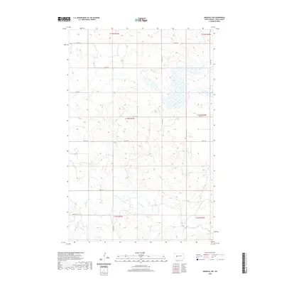
2020 Map of Marshall NW
USGS Topo · Published 2020About this map
The Knife River meanders through this portion of Dunn County, defining the drainage patterns of a landscape marked by deep draws and coulees. This 2020 survey illustrates a sparsely populated agricultural region where the section-line road grid is the primary infrastructure. Key thoroughfares such as 12th St SW and 91st Ave SW provide access to the expansive rangeland and fields that characterize the Great Plains environment. The southern portion of the quadrangle is bisected by the watercourse of Deep Cr, which feeds into the larger river system. While largely void of named settlements, the map provides a meticulous record of the Public Land Survey System boundaries, including the intersections of t143n r93w and surrounding townships, which are essential for land title research and identifying specific homestead locations.
Find a feature on this map
18 named features on this map. Tap any name to fly to it.
Don’t see what you’re looking for? This feature index may not catch every label — zoom into the map to look around manually.
Map Details
Editions of this 2020 Marshall NW Map
This is the sole edition of this map. No revisions or reprints were ever made.
Other maps of this area

1953 · Watford City
USGS Topo · 1:250,000

1957 · Watford City
USGS Topo · 1:250,000

1967 · Watford City
USGS Topo · 1:250,000

1973 · Marshall SE
USGS Topo · 1:24,000

1973 · Marshall SW
USGS Topo · 1:24,000

1973 · Ziner Butte
USGS Topo · 1:24,000
1973 · Hirschville
USGS Topo · 1:24,000

1973 · Halliday
USGS Topo · 1:24,000

1973 · Dunn Center
USGS Topo · 1:24,000

1973 · Werner
USGS Topo · 1:24,000