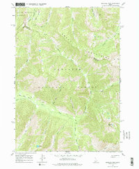
1964 Map of Marshall Peak
USGS Topo · Published 1979About this map
Silver King Mine, Ruby Mine, and Pilgrim Mine represent the industrial history of this high-elevation landscape where the Smoky Mountains meet the Sawtooth Range. The 1964 field check captures the headwaters of the South Fork Boise River and the complex drainage system of the Ross Fork Basin, which is accessible only via a network of Jeep Trails. Boundary lines for both the Boise National Forest and Sawtooth National Forest intersect here, along with the county line between Blaine and Camas. The terrain is defined by steep gulches like Eureka Gulch and Jakes Gulch, while high-altitude water bodies such as Perkins Lake sit beneath the prominent Marshall Peak. This survey provides a record of the mid-century mining infrastructure and primitive transit routes that remained active in this remote interior of Idaho.
Find a feature on this map
29 named features on this map. Tap any name to fly to it.
Don’t see what you’re looking for? This feature index may not catch every label — zoom into the map to look around manually.
Map Details
Editions of this 1964 Marshall Peak Map
2 editions found
Other maps of this area

1894 · Rocky Bar
USGS Topo · 1:125,000

1900 · Sawtooth
USGS Topo · 1:125,000

1955 · Hailey
USGS Topo · 1:250,000

1959 · Hailey
USGS Topo · 1:250,000

1962 · Hailey
USGS Topo · 1:250,000

1963 · Alturas Lake
USGS Topo · 1:24,000

1964 · Frenchman Creek
USGS Topo · 1:24,000

1964 · Ross Peak
USGS Topo · 1:24,000
1964 · Snowyside Peak
USGS Topo · 1:24,000

1964 · Marshall Peak
USGS Topo · 1:24,000