
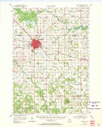
1954 Map of Marshfield
USGS Topo · Published 1956About this map
Marshfield serves as the industrial and medical hub of Wood and Marathon counties in this mid-century survey, anchored by the prominent St Josephs Hospital and the nearby Columbus High Sch. The city's growth is tied to the intersection of the Chicago and North Western and the Minneapolis St Paul and Sault Ste Marie railroads, which facilitated its development as a regional center. Outside the city, the landscape is defined by dairy-belt agricultural activity, evidenced by the University of Wisconsin Experimental Farm and specialized institutions like the County Asylum.
Find a feature on this map
86 named features on this map. Tap any name to fly to it.
Don’t see what you’re looking for? This feature index may not catch every label — zoom into the map to look around manually.
Map Details
Editions of this 1954 Marshfield Map
2 editions found
Other maps of this area

1902 · Marathon
USGS Topo · 1:125,000

1953 · Abbotsford
USGS Topo · 1:48,000

1953 · Marathon
USGS Topo · 1:48,000

1953 · Stratford
USGS Topo · 1:48,000

1953 · Eau Claire
USGS Topo · 1:250,000

1954 · Granton
USGS Topo · 1:62,500

1955 · Green Bay
USGS Topo · 1:250,000

1956 · Milladore
USGS Topo · 1:48,000

1957 · Wisconsin Rapids
USGS Topo · 1:48,000

1957 · Pittsville
USGS Topo · 1:48,000