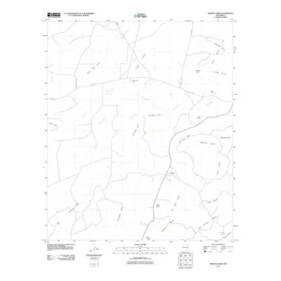
2010 Map of Martha Creek
USGS Topo · Published 2010About this map
Indian Basin and the industrial Indian Basin Plant dominate the northern landscape of this Eddy County quadrangle. The terrain is defined by an intricate network of drainage systems, including the prominent Rocky Arroyo and Dunnaway Draw, which carve through the high desert toward the Seven Rivers in the northeast. This 2010 survey illustrates a region where land use is split between energy infrastructure and traditional cattle ranching, marked by family-named properties like Lee Ranch, Smith Ranch, and Jones Ranch. To the south, the elevation rises toward the expansive Azotea Mesa, guarded by landmarks such as Cone Butte and Lookout Point. These features, along with localized water sources like Weldy Tank and Rock Waterhole Canyon, highlight the essential water management required in this arid New Mexico environment.
Find a feature on this map
33 named features on this map. Tap any name to fly to it.
Don’t see what you’re looking for? This feature index may not catch every label — zoom into the map to look around manually.
Map Details
Editions of this 2010 Martha Creek Map
This is the sole edition of this map. No revisions or reprints were ever made.
Other maps of this area

1940 · Bandanna Point
USGS Topo · 1:62,500

1943 · Bandanna Point
USGS Topo · 1:62,500

1943 · West Carlsbad
USGS Topo · 1:62,500

1945 · West Carlsbad
USGS Topo · 1:62,500

1954 · Seven Rivers
USGS Topo · 1:24,000

1954 · Carlsbad
USGS Topo · 1:250,000

1957 · Foster Ranch
USGS Topo · 1:24,000

1957 · Box Canyon Ranch
USGS Topo · 1:24,000

1958 · Carlsbad
USGS Topo · 1:250,000
1978 · Bandanna Point
USGS Topo · 1:24,000