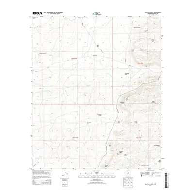
2013 Map of Martha Creek
USGS Topo · Published 2013About this map
Indian Basin and the southeastern reaches of the Guadalupe Mountains define this section of Eddy County, where high desert terrain is etched by a complex network of dry draws and canyons. The landscape is marked by isolated outposts of ranching life, including the Lee Ranch, Smith Ranch, and Polk Ranch, connected by rugged paths like Marathon Rd and Ponderosa Pine Rd. High points such as The Tepee and Lookout Point provide orientation across the mesas, while names like Stinking Draw and Deadman Draw offer a glimpse into the nomenclature of early frontier navigation. The drainage pattern, dominated by Rocky Arroyo and Martha Cr, illustrates the hydrological flow from the foothills toward the Pecos River valley to the east. This survey captures the intersection of established livestock heritage and the geographic isolation of the Permian Basin's western fringe.
Find a feature on this map
40 named features on this map. Tap any name to fly to it.
Don’t see what you’re looking for? This feature index may not catch every label — zoom into the map to look around manually.
Map Details
Editions of this 2013 Martha Creek Map
This is the sole edition of this map. No revisions or reprints were ever made.
Other maps of this area

1940 · Bandanna Point
USGS Topo · 1:62,500

1943 · Bandanna Point
USGS Topo · 1:62,500

1943 · West Carlsbad
USGS Topo · 1:62,500

1945 · West Carlsbad
USGS Topo · 1:62,500

1954 · Seven Rivers
USGS Topo · 1:24,000

1954 · Carlsbad
USGS Topo · 1:250,000

1957 · Foster Ranch
USGS Topo · 1:24,000

1957 · Box Canyon Ranch
USGS Topo · 1:24,000

1958 · Carlsbad
USGS Topo · 1:250,000
1978 · Bandanna Point
USGS Topo · 1:24,000