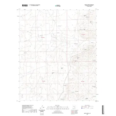
2020 Map of Martha Creek
USGS Topo · Published 2020About this map
Indian Basin and the Seven Rivers Hills define this high desert landscape in Eddy County, where the transition from basin floors to the rising Guadalupe Mountains is marked by a complex network of canyons and draws. The drainage patterns of Rocky Arroyo and Martha Cr carve through the limestone terrain, creating distinct landmarks such as The Tepee and the prominent Azotea Mesa. Local topography is punctuated by family-named features and ranching heritage markers like Old Ranch Knoll and Old Ranch Canyon.
Find a feature on this map
32 named features on this map. Tap any name to fly to it.
Don’t see what you’re looking for? This feature index may not catch every label — zoom into the map to look around manually.
Map Details
Editions of this 2020 Martha Creek Map
This is the sole edition of this map. No revisions or reprints were ever made.
Other maps of this area

1940 · Bandanna Point
USGS Topo · 1:62,500

1943 · Bandanna Point
USGS Topo · 1:62,500

1943 · West Carlsbad
USGS Topo · 1:62,500

1945 · West Carlsbad
USGS Topo · 1:62,500

1954 · Seven Rivers
USGS Topo · 1:24,000

1954 · Carlsbad
USGS Topo · 1:250,000

1957 · Foster Ranch
USGS Topo · 1:24,000

1957 · Box Canyon Ranch
USGS Topo · 1:24,000

1958 · Carlsbad
USGS Topo · 1:250,000
1978 · Bandanna Point
USGS Topo · 1:24,000