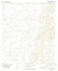
1978 Map of Martha Creek
USGS Topo · Published 1979About this map
Indian Basin dominates the northern half of this landscape, where the energy industry of the late 1970s is evidenced by a dense network of gas wells and a central Gas Plant. This high desert terrain in Eddy County is defined by its drainage systems, including the namesake Martha Creek, Bone Arroyo, and the winding Rocky Arroyo. To the east, the topography rises into the Seven Rivers Hills, while the southern portion of the quadrangle is marked by the prominent Azotea Mesa. Local landmarks such as The Tepee and Cone Butte provide navigational points among the numerous draws and canyons like Old Ranch Canyon and Jones Canyon. The map reveals a working landscape of ranching and resource extraction, with features like Weld Tank and a web of unimproved roads connecting disparate drilling sites across the limestone-scarred ridges and deep alluvial washes.
Find a feature on this map
28 named features on this map. Tap any name to fly to it.
Don’t see what you’re looking for? This feature index may not catch every label — zoom into the map to look around manually.
Map Details
Editions of this 1978 Martha Creek Map
This is the sole edition of this map. No revisions or reprints were ever made.
Other maps of this area

1940 · Bandanna Point
USGS Topo · 1:62,500

1943 · Bandanna Point
USGS Topo · 1:62,500

1943 · West Carlsbad
USGS Topo · 1:62,500

1945 · West Carlsbad
USGS Topo · 1:62,500

1954 · Seven Rivers
USGS Topo · 1:24,000

1954 · Carlsbad
USGS Topo · 1:250,000

1957 · Foster Ranch
USGS Topo · 1:24,000

1957 · Box Canyon Ranch
USGS Topo · 1:24,000

1958 · Carlsbad
USGS Topo · 1:250,000
1978 · Bandanna Point
USGS Topo · 1:24,000