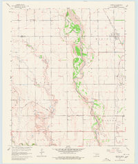
1964 Map of Martha
USGS Topo · Published 1980About this map
Martha stands at the northeastern edge of this southwestern Oklahoma landscape, where the Missouri-Kansas-Texas railroad intersects with local agrarian life. The wide, braided channel of the Salt Fork Red River dominates the central terrain, acting as a natural boundary between township lines. Further south, the small community of Victory and the nearby Childrens Home appear along the route of the Hollis and Eastern rail line. This 1964 field-checked survey documents a transition in the local economy, showing active Oil Wells and several Sandpits along the riverbanks near the southern border. Genealogists will find the locations of both Martha Cem and Victory Cem clearly marked, while hydrologists can trace the drainage of Bitter Creek and Horse Branch into the river system. The map reflects a mid-century Oklahoma interior defined by its reliance on both river-plain agriculture and railroad transport.
Find a feature on this map
21 named features on this map. Tap any name to fly to it.
Don’t see what you’re looking for? This feature index may not catch every label — zoom into the map to look around manually.
Map Details
Editions of this 1964 Martha Map
2 editions found
Other maps of this area

1955 · Lawton
USGS Topo · 1:250,000

1963 · Altus SE
USGS Topo · 1:24,000

1964 · Martha
USGS Topo · 1:24,000

1964 · Altus
USGS Topo · 1:24,000

1964 · Olustee
USGS Topo · 1:24,000

1971 · Blair
USGS Topo · 1:24,000

1971 · Mangum South
USGS Topo · 1:24,000

1971 · Duke
USGS Topo · 1:24,000

1971 · Prairie Hill
USGS Topo · 1:24,000

1971 · Hester
USGS Topo · 1:24,000