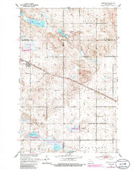
1951 Map of Martin
USGS Topo · Published 1986About this map
The settlement of Martin serves as the focal point for this mid-century survey of the North Dakota prairie, situated at the junction of three counties. The Soo Line railroad cuts diagonally across the landscape, connecting the town to the surrounding agricultural districts of White, Truman, and Hillsdale. This era of the region’s development is clearly defined by its community infrastructure, including the New German Sch No 2, Reform Sch, and Hillsdale Ch. The terrain is punctuated by significant water bodies such as Clear Lake, Alkali Lake, and Johnson Lake, several of which are integrated into the National Waterfowl Production Area. Genealogists will find particular value in the documentation of the Lutheran Cem and Evangelical Cem, situated northwest of the main town site.
Find a feature on this map
26 named features on this map. Tap any name to fly to it.
Don’t see what you’re looking for? This feature index may not catch every label — zoom into the map to look around manually.
Map Details
Editions of this 1951 Martin Map
2 editions found

Other maps of this area

1940 · Aylmer
USGS Topo · 1:62,500

1941 · Selz
USGS Topo · 1:62,500

1945 · Manfred
USGS Topo · 1:62,500

1946 · Sheyenne Lake
USGS Topo · 1:48,000

1947 · Sheyenne Lake
USGS Topo · 1:62,500

1948 · Manfred
USGS Topo · 1:62,500

1950 · Manfred NW
USGS Topo · 1:24,000

1950 · Sheyenne Lake NE
USGS Topo · 1:24,000

1950 · Sheyenne Lake
USGS Topo · 1:24,000
1951 · Harvey
USGS Topo · 1:24,000