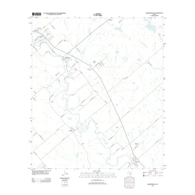
2013 Map of Martindale
USGS Topo · Published 2013About this map
The San Marcos River snakes through this Central Texas landscape, defining the character and development of the riverfront communities of Martindale, Staples, and Fentress. In this 2013 survey, the area retains a distinct rural layout anchored by family-named landmarks and historical burial grounds. Genealogists will find a high density of small cemeteries scattered across the terrain, including Kennedy Cem, Humphrey Cem, Tuttle Cem, and Isidora Cem, many located near old creek crossings like Hemphill Cr and Morrison Cr. Transport and recreation are evident in the proximity of Fentress Airpark and the various named lakes, such as Langford Lake and Grouskay-Fisher Lake, which support the agricultural and social life of the region. The map captures a moment where traditional land use meets modern rural residential growth, seen in the branching road networks of Martindale Falls Rd and Scull Rd near the river’s edge.
Find a feature on this map
87 named features on this map. Tap any name to fly to it.
Don’t see what you’re looking for? This feature index may not catch every label — zoom into the map to look around manually.
Map Details
Editions of this 2013 Martindale Map
This is the sole edition of this map. No revisions or reprints were ever made.
Other maps of this area

1911 · San Marcos
USGS Topo · 1:125,000

1919 · San Marcos
USGS Topo · 1:125,000

1929 · Luling
USGS Topo · 1:62,500

1930 · Lockhart
USGS Topo · 1:62,500

1930 · Seguin
USGS Topo · 1:62,500

1953 · Seguin
USGS Topo · 1:250,000

1958 · Seguin
USGS Topo · 1:250,000

1963 · Lockhart North
USGS Topo · 1:24,000
1964 · Kingsbury
USGS Topo · 1:24,000
1964 · Martindale
USGS Topo · 1:24,000