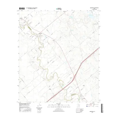
2016 Map of Martindale
USGS Topo · Published 2016About this map
The San Marcos River snakes through the heart of this Central Texas landscape, defining the border between Caldwell Co and Guadalupe Co. The river's tight, meandering oxbows are flanked by high points like Adams Bluff and a series of agricultural and small residential clusters. The settlement of Martindale serves as a focal point near the northern bend, while Staples and Fentress anchor the southern reaches of the quadrangle.
Find a feature on this map
85 named features on this map. Tap any name to fly to it.
Don’t see what you’re looking for? This feature index may not catch every label — zoom into the map to look around manually.
Map Details
Editions of this 2016 Martindale Map
This is the sole edition of this map. No revisions or reprints were ever made.
Other maps of this area

1911 · San Marcos
USGS Topo · 1:125,000

1919 · San Marcos
USGS Topo · 1:125,000

1929 · Luling
USGS Topo · 1:62,500

1930 · Lockhart
USGS Topo · 1:62,500

1930 · Seguin
USGS Topo · 1:62,500

1953 · Seguin
USGS Topo · 1:250,000

1958 · Seguin
USGS Topo · 1:250,000

1963 · Lockhart North
USGS Topo · 1:24,000
1964 · Kingsbury
USGS Topo · 1:24,000
1964 · Martindale
USGS Topo · 1:24,000