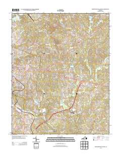
2013 Map of Martinsville East
USGS Topo · Published 2013About this map
Hilltop and the surrounding eastern suburbs of Martinsville characterize this 2013 landscape, where residential development meets the traditional industrial and sporting heritage of Henry County. The southern portion of the map is anchored by the Martinsville Speedway, a landmark of American racing culture, situated near the banks of the Smith River. The map reveals a transition from the dense street grids of older communities like Old Liberty and Fontaine to the winding suburban enclaves of Chatmoss and Laurel Park.
Find a feature on this map
246 named features on this map. Tap any name to fly to it.
Don’t see what you’re looking for? This feature index may not catch every label — zoom into the map to look around manually.
Map Details
Editions of this 2013 Martinsville East Map
This is the sole edition of this map. No revisions or reprints were ever made.
Other maps of this area

1922 · Callands
USGS Topo · 1:48,000

1924 · Martinsville
USGS Topo · 1:48,000

1924 · Draper
USGS Topo · 1:48,000

1924 · Callands
USGS Topo · 1:62,500

1925 · Rocky Mount
USGS Topo · 1:48,000

1926 · Martinsville
USGS Topo · 1:62,500

1926 · Draper
USGS Topo · 1:62,500

1927 · Rocky Mount
USGS Topo · 1:62,500

1927 · Martinsville
USGS Topo · 1:62,500

1944 · Martinsville
USGS Topo · 1:62,500