
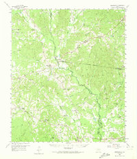
1958 Map of Martinsville
USGS Topo · Published 1959About this map
El Camino Real traces the southern boundary of this East Texas landscape, following the historic corridor through Chireno where the Angelina and Neches River Railroad meets the highway. The terrain is defined by the winding course of Attoyac Bayou, which serves as a natural border between Nacogdoches, Shelby, and San Augustine counties. This mid-century survey reveals a dense network of rural life, anchored by numerous country churches and cemeteries that mark the family heritage of the region.
Find a feature on this map
70 named features on this map. Tap any name to fly to it.
Don’t see what you’re looking for? This feature index may not catch every label — zoom into the map to look around manually.
Map Details
Editions of this 1958 Martinsville Map
2 editions found
Other maps of this area

1949 · Lufkin
USGS Topo · 1:62,500

1949 · Platt
USGS Topo · 1:24,000

1950 · Platt
USGS Topo · 1:24,000

1952 · Nacogdoches
USGS Topo · 1:62,500

1953 · Palestine
USGS Topo · 1:250,000

1957 · Palestine
USGS Topo · 1:250,000

1958 · Center
USGS Topo · 1:62,500

1958 · Broaddus
USGS Topo · 1:62,500

1958 · San Augustine
USGS Topo · 1:62,500

1958 · Timpson
USGS Topo · 1:62,500