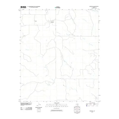
2010 Map of Maryneal
USGS Topo · Published 2010About this map
Maryneal serves as the primary settlement hub in this part of Nolan County, where the high plains landscape is defined by an intricate network of drainage systems. The town is situated along the intersection of Co RD 240 and Co RD 273, just east of the Maryneal Cemetery. This 2010 survey illustrates the sparse but structured road network required for ranching and transit in West Texas, featuring state routes like FM 1170 that connect the isolated community to the wider region. The area's topography is carved by numerous watercourses including Robertson Creek, Wilson Creek, and Eagle Creek, which flow through the dry landscape. Tracing these creeks, such as Brushy Robertson Creek and Cas Russell Creek, reveals the natural patterns of the terrain that have historically dictated road placement and land use for generations of local families.
Find a feature on this map
15 named features on this map. Tap any name to fly to it.
Don’t see what you’re looking for? This feature index may not catch every label — zoom into the map to look around manually.
Map Details
Editions of this 2010 Maryneal Map
This is the sole edition of this map. No revisions or reprints were ever made.
Other maps of this area

1893 · Sweetwater
USGS Topo · 1:125,000

1954 · Big Spring
USGS Topo · 1:250,000

1958 · Big Spring
USGS Topo · 1:250,000

1962 · Sanco
USGS Topo · 1:24,000

1969 · Bench Mountain
USGS Topo · 1:24,000

1969 · Blackwell NE
USGS Topo · 1:24,000

1969 · Maryneal
USGS Topo · 1:24,000
1969 · Dew Drop Creek
USGS Topo · 1:24,000
1969 · Blackwell SW
USGS Topo · 1:24,000
1969 · Blackwell
USGS Topo · 1:24,000