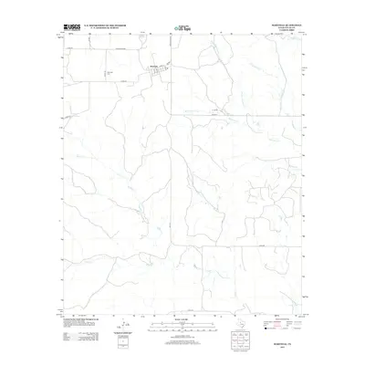
2012 Map of Maryneal
USGS Topo · Published 2012About this map
Maryneal serves as the central hub of this West Texas landscape, located at the intersection of Main St and Ranch Road 608. The settlement is defined by a grid of streets including 1st St and 6th St, with the Maryneal Cem situated to the west along Co Rd-132. This 2012 survey illustrates a terrain deeply etched by a network of seasonal watercourses, where drainage patterns flow toward larger systems like Eagle Cr and Wilson Cr. The presence of numerous ranch roads, such as Co Rd-273 and Co Rd-133, highlights the area's ongoing agricultural and ranching character, showing how local transit routes have adapted to the winding paths of Robertson Cr and Cas Russell Cr.
Find a feature on this map
24 named features on this map. Tap any name to fly to it.
Don’t see what you’re looking for? This feature index may not catch every label — zoom into the map to look around manually.
Map Details
Editions of this 2012 Maryneal Map
This is the sole edition of this map. No revisions or reprints were ever made.
Other maps of this area

1893 · Sweetwater
USGS Topo · 1:125,000

1954 · Big Spring
USGS Topo · 1:250,000

1958 · Big Spring
USGS Topo · 1:250,000

1962 · Sanco
USGS Topo · 1:24,000

1969 · Bench Mountain
USGS Topo · 1:24,000

1969 · Blackwell NE
USGS Topo · 1:24,000

1969 · Maryneal
USGS Topo · 1:24,000
1969 · Dew Drop Creek
USGS Topo · 1:24,000
1969 · Blackwell SW
USGS Topo · 1:24,000
1969 · Blackwell
USGS Topo · 1:24,000