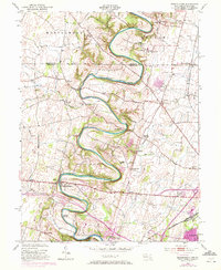
1953 Map of Mason-Dixon
USGS Topo · Published 1972About this map
Conococheague Creek snakes through the heart of this borderland, its deep meanders defining the topography between Franklin and Washington Counties. The map records a landscape anchored by small crossroads and rural institutions, where the Mason and Dixon Line serves as both a political boundary and a physical roadbed for a portion of its length. Settlement patterns follow the winding water and rail lines, with clusters at Worleytown, Coseytown, and Fairview. Along the creek's lower bends, industry and agriculture converge at sites like Wilson Quarry and the numerous small runs that once powered local mills, such as Fairview Mill Run. The cultural footprint of the mid-20th century is evident in the network of country schools, including Locust Level and White Pine, alongside historic congregations at Reiffs and Mt. Zion Churches.
Find a feature on this map
46 named features on this map. Tap any name to fly to it.
Don’t see what you’re looking for? This feature index may not catch every label — zoom into the map to look around manually.
Map Details
Editions of this 1953 Mason-Dixon Map
4 editions found
Other maps of this area

1900 · Mercersburg
USGS Topo · 1:62,500

1902 · Chambersburg
USGS Topo · 1:62,500

1902 · Mercersburg
USGS Topo · 1:62,500

1909 · Hagerstown
USGS Topo · 1:48,000

1912 · Hagerstown
USGS Topo · 1:62,500

1912 · Williamsport
USGS Topo · 1:62,500

1942 · Hagerstown
USGS Topo · 1:125,000

1943 · Hagerstown
USGS Topo · 1:125,000

1943 · Mercersburg
USGS Topo · 1:24,000

1943 · Chambersburg
USGS Topo · 1:62,500